Cuatro Calas, biodiversity and unspoiled coast across 550 protected acres
A landscape of cliffs, islets, and ancient esparto-grass kilns
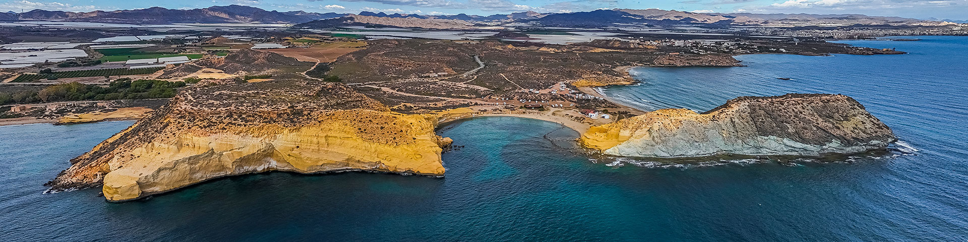
Between the Murcian coast and the province of Almería lies the Cuatro Calas Protected Landscape, a 550-acre area where sandy beaches, semi-desert hills, and ravines converge in an environment of high ecological value. Also declared a Site of Community Importance within the Natura 2000 Network, this coastal stretch in the town of Águilas combines biodiversity, geological uniqueness, and amenities that allow visitors to enjoy an unspoiled Mediterranean. Calarreona, the longest and widest beach, serves as a natural gateway to the area. With about 1,500 feet of sandy beach, a south-facing orientation, and a central promontory dividing it into two sectors, it offers marked access points from the Vera road, a parking area, and a gentle slope into the sea with a sandy bottom. It also enjoys lifeguard and first-aid services, as well as bathing assistance for persons with reduced mobility, including accessible points, boardwalks, and shaded areas. Nearby, La Higuerica Beach stands out for its family-friendly atmosphere, stretching along 650 feet. With its greyish fine sand, transparent waters, and gentle waves, it is located in front of the rocky islet known as La Cama de los Novios. Situated within the protected landscape and designated as a smoke-free beach, it maintains high visitor numbers during the peak season without losing its natural character.
")
La Carolina, with its semi-urban nature and approximately 820 feet long, combines tranquility and biodiversity in a sheltered setting. Its fine sand and gradual entry into the sea make it a suitable option for families, while its location within the Natura 2000 Network highlights the area’s environmental significance. On the border with the province, Los Cocedores or Cala Cerrada present about nearly 500 feet of golden sand, cliffs, and rock formations of great geological interest. Their ancient structures used for esparto-grass drying, featuring cavities carved into rock, add an ethnographic element to a landscape of natural pools and crystal-clear waters. The setting is completed by the Cuatro Calas Juan Francisco Mota Poveda circular hiking route—approximately 2.5 miles long and linking beaches, the salt marsh of Cañada Brusca, viewpoints, and volcanic promontories such as Punta Parda. This low-difficulty and freely accessible route offers the chance to understand ancient tropical seabeds, volcanic events, and unique habitats where species such as the Murcian jujube, the Greek tortoise, and spiny-footed lizard thrive. Cuatro Calas represents a Mediterranean coastline where conservation, accessibility, and landscape diversity coexist in perfect equilibrium, creating the ideal setting for initiatives seeking nature, authenticity, and experience in a protected space.
Location
Águilas is located in the southwest of the Region of Murcia, along the Mediterranean coast of southeastern Spain and near the border with the province of Almería. By road, it is mainly accessed via the RM–11, which connects to the Mediterranean A–7 highway. It also enjoys rail connections along the Murcia–Águilas line. The nearest airports are the Murcia Region International Airport and Almería Airport.